TARGIT
Mission information
- Name
- TARGIT
- Satellite ID
- FETN-4700-8802-0875-2803
- Temporary NORAD ID
- 99434
- Followed NORAD ID
- 51441
- Website
- https://www.ssdl.gatech.edu/research/projects/tethering-and-ranging-mission-georgia-institute-technology-targit
- Country of Origin
-
United States of America
Status
Decayed
Satellite has re-entered
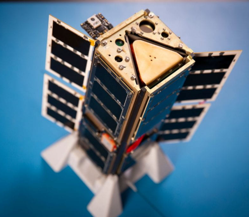
Image
Mission timeline
- Launch Date
- 2021-12-21T10:06:00+00:00
- Deploy Date
- 2022-01-26T13:40:00+00:00
- Decay Date
- 2022-11-16T00:00:00+00:00
Description
TARGIT is a 3U CubeSat mission sponsored by NASA’s Undergraduate Student Instrument Program (USIP), and it will deploy a small inflatable on a tether and create a 3D image of the target using a miniaturized LiDAR imaging camera. The ultimate objective of this LiDAR system is to enable future planetary small satellite missions to gather valuable topographic, navigation, and reconnaissance data with a low size, weight, and power (SWaP) instrument.
SatNOGS Links
Mode U - FSK9k6
- Type
- Transmitter
- Service
- Amateur
- Downlink Mode
- FSK
- Downlink Frequency
- 437285000
- Baud
- 9600
- IARU Coordination
- IARU Coordinated
Most Recent Observers (last 24h)
No observations recorded for TARGIT in the last 24h
Data Frames Decoded - 30 Days
There is no decoded data for this satellite in the last 30
days.
Decoder: TARGIT Telemetry
- Script Name
- targit
- Decoder Fields
- Click here