- Name
- CAS-10
- Alternate Names
- HO-119, XW-4, HOPE-4
- Satellite ID
- TLZR-1993-2564-0036-4315
- NORAD ID
- 54816
- Countries of Origin
-
China
Macao
Satellite has re-entered
- Launch Date
- 2022-12-18T00:00:00+00:00
- Decay Date
- 2023-03-14T19:18:12+00:00
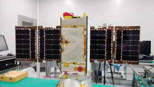
CAMSAT’s CAS-10 is an 8U CubeSat that will carry an Amateur Radio VHF to UHF linear transponder for SSB communications.
Hope-4 (XW-4) CAS-10 is an 8U CubeSat, approx 228 x455x 100mm, with a mass of 12kg. The satellite will carry:
-
A VHF uplink and UHF downlink linear transponder with a bandwidth of 30kHz. This transponder will work all day during the life cycle of the satellite, and amateur radio enthusiasts around the globe can use it for two-way radio relay communications.
-
A camera, and the pictures it takes are stored in the flash memory on the satellite, we have designed a simple remote control system based on DTMF, and amateur radio enthusiasts around the globe can send DTMF commands to download the camera photos.
-
A CW beacon to send satellite telemetry data, which is also a feature that is widely welcomed by amateur radio enthusiasts.
-
A AX.25 4.8k/9.6kbps GMSK telemetry downlink
The satellite is also known as:
Macao Student Science Satellite 1 Macau Student Science Popularization Satellite No. 1
- Type
- Transmitter
- Service
- Amateur
- Downlink Mode
- GMSK
- Downlink Frequency
- 435725000
- Baud
- 4800
- IARU Coordination
- IARU Coordinated
- Type
- Transponder
- Service
- Amateur
- Downlink Mode
- USB
- Downlink Frequency
- 435165000
- Uplink Mode
- LSB
- Downlink High
- 435195000
- Uplink Frequency
- 145855000
- Uplink High
- 145885000
- Inverted
- Yes
- IARU Coordination
- IARU Coordinated
- Type
- Transmitter
- Service
- Amateur
- Downlink Mode
- CW
- Downlink Frequency
- 435575000
- Baud
- 22
- IARU Coordination
- IARU Coordinated
- Type
- Transmitter
- Service
- Amateur
- Downlink Mode
- BPSK
- Downlink Frequency
- 435185000
- Baud
- 19200
No observations recorded for CAS-10 in the last 24h